


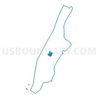
Voting District 7500128, New York County, New York
About
Outline

Summary
| Unique Area Identifier | 632097 |
| Name | Voting District 7500128 |
| County | New York County |
| State | New York |
| Area (square miles) | 0.33 |
| Land Area (square miles) | 0.33 |
| Water Area (square miles) | 0.01 |
| % of Land Area | 97.94 |
| % of Water Area | 2.06 |
| Latitude of the Internal Point | 40.77226710 |
| Longtitude of the Internal Point | -73.97473920 |
Maps

Graphs
Select a template below for downloading or customizing gragh for Voting District 7500128, New York County, New York


Neighbors
Neighoring Voting District (by Name) Neighboring Voting District on the Map
- Voting District 6700039, New York County, NY
- Voting District 6700040 6700041, New York County, NY
- Voting District 6700042 6700043, New York County, NY
- Voting District 6700118, New York County, NY
- Voting District 7300039, New York County, NY
- Voting District 7300041, New York County, NY
- Voting District 7300047, New York County, NY
- Voting District 7300048, New York County, NY
- Voting District 7300050, New York County, NY
- Voting District 7300058, New York County, NY
- Voting District 7500106, New York County, NY
- Voting District 7500107 7500122, New York County, NY
- Voting District 7500108, New York County, NY
- Voting District 7500111, New York County, NY
- Voting District 7500112, New York County, NY
- Voting District 7500113, New York County, NY
- Voting District 7500114, New York County, NY
- Voting District 7500115, New York County, NY
- Voting District 7500116, New York County, NY
- Voting District 7500117, New York County, NY
- Voting District 7500118, New York County, NY
- Voting District 7500119, New York County, NY
- Voting District 7500120, New York County, NY
- Voting District 7500123, New York County, NY
- Voting District 7500126, New York County, NY
Top 10 Neighboring County Subdivision (by Population) Neighboring County Subdivision on the Map
Top 10 Neighboring Place (by Population) Neighboring Place on the Map
Top 10 Neighboring Unified School District (by Population) Neighboring Unified School District on the Map
Top 10 Neighboring State Legislative District Lower Chamber (by Population) Neighboring State Legislative District Lower Chamber on the Map
- Assembly District 75, NY (149,377)
- Assembly District 67, NY (134,810)
- Assembly District 73, NY (129,766)
Top 10 Neighboring State Legislative District Upper Chamber (by Population) Neighboring State Legislative District Upper Chamber on the Map
Top 10 Neighboring 111th Congressional District (by Population) Neighboring 111th Congressional District on the Map
Top 10 Neighboring Census Tract (by Population) Neighboring Census Tract on the Map
- Census Tract 157, New York County, NY (10,751)
- Census Tract 153, New York County, NY (9,320)
- Census Tract 137, New York County, NY (6,471)
- Census Tract 149, New York County, NY (5,842)
- Census Tract 145, New York County, NY (5,542)
- Census Tract 130, New York County, NY (4,195)
- Census Tract 122, New York County, NY (3,633)
- Census Tract 114.01, New York County, NY (1,412)
- Census Tract 112.01, New York County, NY (992)
- Census Tract 112.02, New York County, NY (441)
Top 10 Neighboring 5-Digit ZIP Code Tabulation Area (by Population) Neighboring 5-Digit ZIP Code Tabulation Area on the Map
- 10023, NY (60,998)
- 10021, NY (43,631)
- 10019, NY (42,870)
- 10065, NY (32,270)
- 10022, NY (31,924)
- 10153, NY (0)